Reference
The Fehmarn Belt Link
The world’s longest immersed tunnel requires careful planning and meticulous preparation. LE34 is responsible for securing the acquisition of land and rights for the Fehmarn project through expropriation and voluntary agreements.

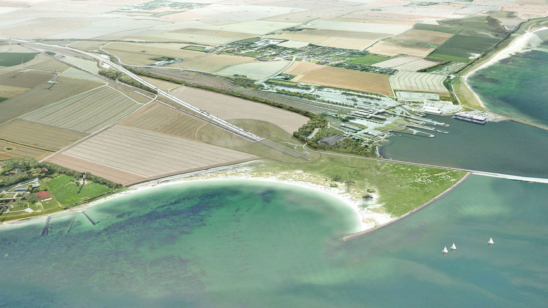
The extensive preparations for the future fixed link under the Fehmarn Belt are already well underway, even though final approval by the German authorities is still pending. At sea, transport tunnels for vehicles and trains will be placed in a channel dredged in the seabed. And on land, roads, train stations and production areas will need to be established and natural reserves replaced. When the tunnel is finished, it will take ten minutes to reach Germany from Denmark by car and seven minutes by train.
LE34’s role in the project
LE34 has been a permanent consultant for the Fehmarn Link since 2010, advising on all types of rights and land acquisition. It is crucial to the project that there is land available for construction and establishment of the approach to the tunnel, the motorway, the new train station and production areas. In 2015, the Danish Parliament therefore adopted a Construction Act whereby the Danish state is entitled to acquire or expropriate the necessary land on a temporary basis. LE34 played a key role in identifying and defining precisely which land was needed and drew up the so-called memorandum of delivery, which forms the basis of the Construction Act.
By means of voluntary agreements and expropriations, we ensure that the Fehmarn Link has access to the land on which the future roads and other land installations will lie. So far, we have helped secure agreements on a wide range of advance acquisitions, calculated compensation and negotiated with landowners on behalf of the Fehmarn Link.

-
Expropriation
State expropriation may be necessary to carry out major construction, energy and infrastructure projects. LE34 handles land and rights acquisition, landowner dialogue and expropriation material for some of Denmark’s largest construction projects.
-
Landowner negotiation
LE34 shows the way – including to a successful landowner negotiation. As the country’s largest chartered surveying firm, we have several property-law specialists with years of experience in expropriation and compensation law, ensuring a fact-based, professional negotiation with landowners and, where relevant, the authorities.
-
GIS
Municipalities, utilities, chartered surveyors, engineers, contractors and many others use GIS – Geographic Information System – every day in project planning and operations. At its best, GIS turns geographic data from a large, unmanageable pile into an intuitive, clear system. IT34 develops reliable, time-saving GIS applications that streamline workflows and can optimise everyday work in your organisation.
-
Environmental and EIA screening
Would you like to know more about environmental and EIA screening? Fill in the contact form below and the right specialist will get back to you.
Read More -
Cadastral case processing
Cadastral case processing covers, among other things, subdivision, land transfer, amalgamation and other changes to properties. LE34 carries out the case processing and ensures that the changes are registered correctly.
-
Setting out
Need setting out for your project? LE34 is always ready to set out anything from conservatories to major structures. Rapid call-out or planned procedure – we are ready with x, y and levels when the tolerance classes have to be met.
-
Compensation calculation
Would you like to know more about compensation calculation? Fill in the contact form below and the right specialist will get back to you.
Read More -
Risk management
LE34 contributes to risk management in construction, utility, climate and renewable energy projects through analysis, planning and project management. This provides a solid basis for handling risks early in the project.
-
Land consolidation
It almost goes without saying: land consolidation is about distributing the land among the parties. And yet the word says nothing about the most important thing in a land consolidation process: people. And respect for each other’s wishes.
-
Project management
Project management ensures that professional, technical and regulatory processes are coordinated throughout the project. LE34 handles project management in construction, utility and renewable energy projects, with a focus on progress, coordination and documentation.
-
Documentation for the Construction Act
Would you like to know more about documentation for the Construction Act? Fill in the contact form below and the right specialist will get back to you.
Read More
Interdisciplinary team
The team of LE34 staff attached to the Fehmarn Link project consists of chartered land surveyors, lawyers, survey technicians and technical assistants, all of whom provide surveying services of extremely high quality and a high level of expertise. We have developed an in-depth understanding of the Fehmarn project and provide a full range of consultancy services, which also make allowance for unforeseen challenges. Consequently, our consultancy helps prevent potential project delays.
On site at short notice
From our base at LE34’s Maribo office, we perform surveys and set out boundaries and sites in the project area at short notice. We also handle all of the cadastral procedures.
Book a meeting and hear more
Gert Henningsen, chartered land surveyor and project manager, LE34
Our in-depth knowledge of the Fehmarn Link project is the sum of all of the considerations, project details and decisions we have been involved in over many years. And we pass on this knowledge to all parties and suppliers involved in the project.
We negotiate for Fehmarn
Our work to secure the Fehmarn Link’s access and rights to the land they need includes entering into voluntary agreements and agreeing on advance acquisitions and expropriations with the owners of the affected properties and buildings. Our employees’ work is based on their specialist expertise and experience in acquisition of land and rights. However, because LE34 has worked on the Fehmarn Link project since its very beginning, negotiations are also based on our employees’ in-depth knowledge of the individual properties in the project area and the individual landowners.

Specially designed GIS tool
Complex projects require a good overview of the numerous details. LE34 has therefore developed a sophisticated GIS tool specifically for the Fehmarn Link project, accumulating information about property, the layout of the future land installations, roads, tunnel approaches, sites for production areas, replacement of natural reserves, landowners and a wide range of other project data in one place. The GIS tool places individual details at the sites where they belong in the project area. This provides the Fehmarn Link with a valuable tool for keeping track of the project. It is user-friendly and is updated on a regular basis.
Illustrations: Femern A/S
Find out more
Contact us
You are welcome to contact project manager Gert Henningsen if you are interested in further details.
Gert Henningsen
Chartered land surveyor
Director, Expropriation & Land Law
+45 3163 9260
gmh@le34.dk
